
Trail Accessibility Information
Welcome to the trail accessibility guide for our wildlife sanctuaries. We understand that every adventurer has different needs and preferences, so we provide information about the features and terrain of our trails to help you plan an outing you’ll love. Whether you’re a seasoned birdwatcher or just starting out, this resource ensures that you can enjoy the wonders of birding at your own comfort level.
Note that pet animals are prohibited, regardless of whether they’re leashed or not. ONLY trained service animals are allowed.
Trails at all locations are multiuse trails that provide for public nature appreciation and for habitat management including invasive species removal, seed collecting and prescribed burning. Trails are not meant for running due to uneven terrain and potential animal holes.
The trails are open to the public from dawn to dusk and year round. However, in winter snow is not removed from the parking lots and trails, and may be drifted in with snow.
We will continue to add trail information to this webpage as we are able. If you have any particular requests for information, please email Brenna at bmarsicek@swibirds.org. Enjoy your outing!
Cover photo: hikers on a trail at Erstad Prairie (by Elizabeth Palmer)
Choose what kind of trail
Search by location
Fair Meadows Sanctuary (Rock Co.)
Faville Grove Sanctuary (Jefferson Co.)
Goose Pond Sanctuary (Columbia Co.)
Otsego Marsh (Columbia Co.)
Trails 1 Mile or Longer
Lapinski-Kitze (Columbia Co.)
Buddy’s Prairie (Jefferson Co.)
Otsego Marsh Woods Trail (Columbia Co.)
Trails with Shade
Browne Prairie (Columbia Co.)
Big Prairie (Rock Co.)
Barn to Apple Shed Lane (Rock Co.)
Apple Shed Lane to Fork at Heron Pond (Rock Co.)
Buddy’s Prairie (Jefferson Co.)
Otsego Marsh Woods Trail (Columbia Co.)
Fair Meadows Sanctuary Trails (Rock County)
Note that Fair Meadows Sanctuary can be accessed through the many field trips and twice-monthly Birding Days. Register for an upcoming event to get the location information. Spontaneous drop-in visits are not permitted.

Fair Meadows Sanctuary Map. Three accessible trails are marked in purple, blue, and pink.
Big Prairie - marked in purple

Zoomed in view of the Fair Meadows map with the purple dashed lines indicating the Big Prairie trail.

Big Prairie trailhead (photo by Penny Shackelford)
Location: Fair Meadows Sanctuary (register for an upcoming event at Fair Meadows to receive more information about the location)
Route: park at the main parking area below/east of the Red Barn. Walk north through the open mowed grassy area between the woods and the cedar trees to get to the trailhead. Walk west along the grassy trail to get to the Big Prairie Loop.
*****
General Information
Type of trail: loop
Trail length: 0.80 miles (inner perimeter)
Parking: grassy area below/east of the red barn.
Bathrooms: no bathrooms
Trail traffic: few people present/typically low traffic
Trail Terrain
Trail surface: short grass, somewhat uneven
Trail width: 7 ft. for whole trail
Trail cross-slope: max. 4% cross-slope (for about 0.1 miles near start of trail), most of trail has only about 1-2% cross-slope
Trail forward-slope: max. 5% forward-slope from road to trailhead, most of the trail has only about 1-2% forward-slope
Features and Obstacles
Ramps: no ramps
Steps: none
Gates: none
Railings: none
Bird blinds: none
Resting and Shade
Benches: bench at 0.15 miles and 0.25 miles (walking counter-clockwise around loop)
Shade cover: benches have shade, otherwise none
Other
Transportation/construction noise: none
Other potential concerns: trail is on private property, ticks/chiggers present, trail is not lit at night
Barn to Apple Shed Lane - marked in blue

Zoomed in view of the Fair Meadows map with the blue dashed lines indicating the Barn to Apple Shed Lane Parking route.
Location: Fair Meadows Sanctuary (register for an upcoming event at Fair Meadows to receive more information about the location)
Route: park at the main parking area below/east of the Red Barn (northern P on the map). Walk south along the gravel Main Entry Road past the wetlands. Turn right (south) on the grassy Apple Shed Lane and follow that until you get to a small grassy parking area. Return the way you came.
*****
General Information
Type of trail: out-and-back
Trail length: 0.27 miles (one way)
Parking (can park at either end of trail):
Grassy area below/east of the red barn, or
Grassy parking lot on Apple Shed Lane, space for ~4 vehicles, 5% slope to get to main road
Bathrooms: no bathrooms
Trail traffic: few people present/typically low traffic
Trailhead from barn to Apple Shed Lane (photo by Penny Shackelford)
Trail Terrain
Trail surface: gravel on main road, short grass, somewhat uneven on Apple Shed Lane
Trail width: 10 ft. on main road, 7 ft. on Apple Shed Lane
Trail cross-slope: max. 3% cross-slope
Trail forward-slope: max. 6% forward-slope on main road, 5% forward-slope from main road to Apple Shed Lane parking
Features and Obstacles
Ramps: no ramps
Steps: none
Gates: none
Railings: none
Bird blinds: none
Resting and Shade
Benches: none
Shade cover: moderate shade from trees, about 30% shade coverage year-round
Other
Transportation/construction noise: none
Other potential concerns: trail is on private property, ticks/chiggers present, trail is not lit at night
Apple Shed Lane to Fork at Heron Pond - marked in pink

Zoomed in view of the Fair Meadows map with the pink dashed lines indicating the Apple Shed Lane Parking to Fork at Heron Pond route.

Fork from Apple Shed parking to Heron Pond (photo by Penny Shackelford)
Location: Fair Meadows Sanctuary (register for an upcoming event at Fair Meadows to receive more information about the location)
Route: park at the grassy lot on Apple Shed Lane, walk north along the lane until it meets with the Main Entry Road. Turn right (east) to walk past the Petite Woods and to Heron Pond. Return the way you came.
*****
General Information
Type of trail: out-and-back
Trail length: 0.18 miles (one way)
Parking: grassy parking lot on Apple Shed Lane, space for ~4 vehicles, 5% slope to get to main road
Bathrooms: no bathrooms
Trail traffic: few people present/typically low traffic
Trail Terrain
Trail surface: gravel on main road, short grass, somewhat uneven on Apple Shed Lane
Trail width: 10 ft. on main road, 7 ft. on Apple Shed Lane
Trail cross-slope: max. 3% cross-slope
Trail forward-slope: max. 5% forward-slope to from Apple Shed Lane parking to main road
Features and Obstacles
Ramps: no ramps
Steps: none
Gates: none
Railings: none
Bird blinds: none
Resting and Shade
Benches: none
Shade cover: moderate shade from trees, about 30% shade coverage year-round
Other
Transportation/construction noise: none
Other potential concerns: trail is on private property, ticks/chiggers present, trail is not lit at night
Faville Grove Sanctuary Trails
Because most of the trails at Faville Grove are not regularly mowed, trails in this sanctuary are not typically accessible to individuals with physical disabilities.

Faville Grove Sanctuary Map. One accessible trail is marked in pink.

Zoomed in view of the Faville Grove map with the pink dashed lines indicating the Buddy’s Prairie Parking to Faville Grove Bog route.

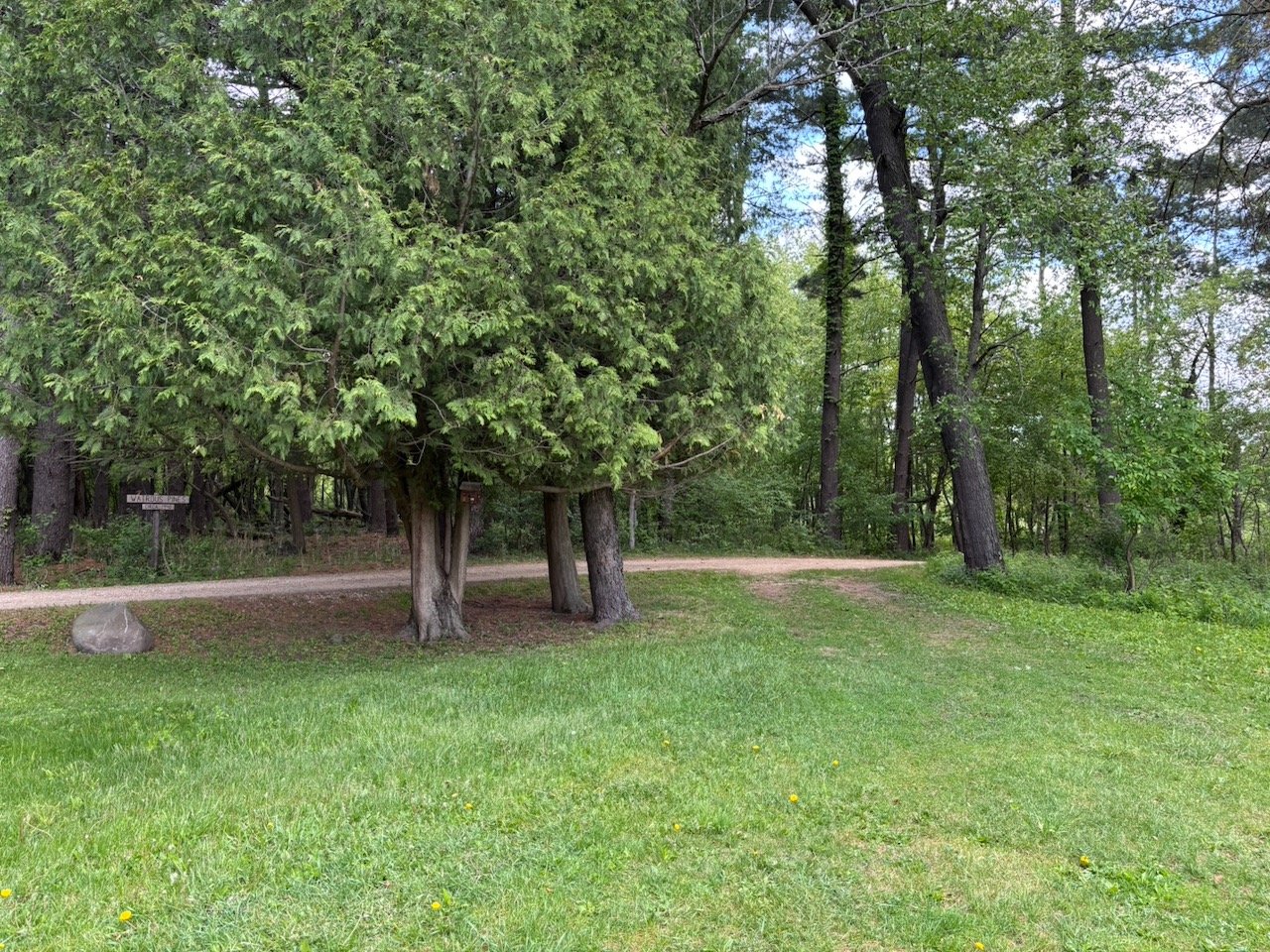
Buddy’s Prairie trailhead (photo by SoWBA)

Buddy’s Prairie trail (photo by SoWBA)
Buddy’s Prairie to the Bog
Location: N7710 Wisconsin 89, Waterloo, WI.
GPS Coordinates: 43.1283618, -88.9144634. Google Map
Route: park either in the grass to the right of the gravel driveway, or along Highway 89. Walk north through the gate and head to the right through the yard of the farmhouse. The trailhead will be found at the Northeast corner of the yard behind the shed, about 15 meters from the front gate.
*****
General Information
Location: Faville Grove Sanctuary
Type of trail: out-and-back
Trail length: 0.4 miles to lookout of Faville Grove Bog
Parking: One spot available in the grass on the right side of the gravel driveway (do not block gate or maintenance road north of driveway). Also can park well off the road along Highway 89, though there is a slope when doing so.
Bathrooms: no bathrooms
Trail traffic: few people present/typically low traffic
Trail Terrain
Trail surface: trail is roughly mowed prairie, often with a mulch of grasses present, some muddy sections
Trail width: 6 ft. wide, at about 0.3 miles becomes ~2 ft. wide
Trail cross-slope: max. 3% cross-slope
Trail forward-slope: 1-2% forward-slope for most of trail, max. 5% forward-slope around 0.3 miles to reach lookout
Features and Obstacles
Ramps: no ramps
Steps: none
Gates: none
Railings: none
Bird blinds: none
Resting and Shade
Benches: none
Shade cover: one area contains a black oak savanna and offers shade, the rest is open prairie without shade
Other
Transportation/construction noise: nearby traffic from highway
Other potential concerns: ticks/chiggers present, trail is not lit at night, driveway may not be maintained during winter
Goose Pond Sanctuary Trails (Columbia County)

Goose Pond Sanctuary Map. Three accessible trails are marked in purple, blue, and pink.
Browne Prairie Outlook

Zoomed in view of the Goose Pond map with the purple dashed lines indicating the Browne Prairie trail.

Browne Prairie trailhead (photo by Emma Raasch/SoWBA)

The Browne Prairie Overlook bench with shade (photo by Brenna Marsicek/SoWBA)
Location: Kampen Road, approximately 1/4 mile west of the driveway for W7503 Kampen Rd., Arlington.
GPS Coordinates: 43.3229474, -89.395296. Google Map
Route: Park in the small grass lot off of Kampen Rd. Take the middle trail that goes south. At the next intersection, take the trail to the left to arrive at the bench and overlook. Return the way you came.
*****
General Information
Type of trail: out-and-back
Trail length: 0.15 miles to lookout (0.3 miles with return)
Parking: small grass lot off of main road, not on a slope but the surface is slightly uneven and can become muddy from heavy rain
Bathrooms: no bathrooms
Trail traffic: few people present/typically low traffic
Trail Terrain
Trail surface: short grass, somewhat uneven
Trail width: 8 ft. for whole trail
Trail cross-slope: max. 4% cross-slope, most of trail is about 2-3% cross-slope
Trail forward-slope: max. 3% forward slope, most of trail is about 2% forward-slope
Features and Obstacles
Ramps: no ramps
Steps: none
Gates: none
Railings: none
Bird blinds: none
Resting and Shade
Benches: bench at outlook (0.15 miles)
Shade cover: bench is covered, otherwise none
Other
Transportation/construction noise: traffic from road (usually minimal)
Other potential concerns: ticks/chiggers present, trail is not lit at night
Lapinski-Kitzke Prairie

Zoomed in view of the Goose Pond map with the aqua dashed lines indicating the Lapinski-Kitze trail.

Lapinski-Kitze Prairie trailhead (photo by Emma Raasch/SoWBA)
Location: Goose Pond Rd., approximately 500 feet north of the intersection with Kampen Rd., Arlington.
GPS Coordinates: 43.3265415, -89.3690251. Google Map
Route: Park in the small grass lot off of Goose Pond Rd. Take either trail to the north or south, and turning at each intersection to remain on the outer-most path.
*****
General Information
Type of trail: loop
Trail length: 1.9 miles around outer perimeter
Parking: small grass lot off of main road, entrance from road is on a slope but the lot itself is flat, surface is slightly uneven and can become muddy from heavy rain
Bathrooms: no bathrooms
Trail traffic: few people present/typically low traffic
Trail Terrain
Trail surface: short grass, uneven
Trail width: 8 ft. for whole trail
Trail cross-slope: max. 4% cross-slope, much of the trail has 2-3% cross-slope
Trail forward-slope: max. 5% forward-slope (occurs at 0.1 miles to the right of entrance, lasts for about 0.1 miles with bench shortly after), most of the trail has about 2-3% forward-slope
Features and Obstacles
Ramps: no ramps
Steps: none
Gates: none
Railings: none
Bird blinds: none
Resting and Shade
Benches: bench at 0.25 miles to the right of entrance
Shade cover: none
Other
Transportation/construction noise: traffic from road (usually minimal), train tracks nearby
Other potential concerns: ticks/chiggers present, trail is not lit at night, shares border with private property
Erstad Prairie

Zoomed in view of the Goose Pond map with the pink dashed lines indicating the Erstad Prairie trail.

Erstad Prairie trailhead (photo by Emma Raasch/SoWBA)
Location: Northern most point of Harvey Rd., Poynette, WI.
GPS Coordinates: 43.3433, -89.3024. Google Map
Route: Park in the small grass lot off of Harvey Rd. Take either trail to the north or east, and turning at each intersection to remain on the outer loop.
*****
General Information
Type of trail: loop
Trail length: 0.84 miles
Parking: small grass lot off of main road, not on a slope but the surface is slightly uneven and can become muddy from heavy rain
Bathrooms: no bathrooms
Trail traffic: few people present/typically low traffic
Trail Terrain
Trail surface: short grass, somewhat uneven
Trail width: 8 ft. for whole trail
Trail cross-slope: max. 4% cross-slope (for about 0.1 miles near start of trail), most of trail has only about 1-2% cross-slope
Trail forward-slope: max. 2% forward-slope, most of the trail has only about 1% forward-slope
Features and Obstacles
Ramps: no ramps
Steps: none
Gates: none
Railings: none
Bird blinds: none
Resting and Shade
Benches: none
Shade cover: none
Other
Transportation/construction noise: traffic from road (usually minimal)
Other potential concerns: ticks/chiggers present, trail is not lit at night, entrance is next to private property
*****
Otsego Marsh Trails (Columbia County)

Otsego Marsh Map. Two accessible trails are marked in purple and pink.

Zoomed in view of the Otsego Marsh map with the purple dashed lines indicating the Woods Trail.

Otsego Marsh Woods Trail (photo by Eva Whitney)
Otsego Marsh Woods Trail
Location: 3382 Old Co Rd F, Rio, WI.
GPS Coordinates: 43.403004, -89.224781. Google Map
Route: park in the Southern Wisconsin Bird Alliance lot on the East side of Old Co Rd F; the trail begins on the East side of the parking lot.
*****
General Information
Location: Otsego Marsh
Type of trail: loop
Trail length: 1.35 miles
Parking: ~2 spots available in grassy lot on the East side of Old Co Rd F
Bathrooms: no bathrooms
Trail traffic: few people present/typically low traffic
Trail Terrain
Trail surface: trail is roughly mowed grass, some muddy sections
Trail width: 6 ft. or wider throughout the trail
Trail cross-slope: max. 3.5% cross-slope
Trail forward-slope: 1-2% forward-slope for most of trail, max. 4% forward-slope for the first ~0.1 miles of the trail
Features and Obstacles
Ramps: no ramps
Steps: none
Gates: none
Railings: none
Bird blinds: none
Resting and Shade
Benches: bench at 0.35 miles, 0.8 miles, and 0.9 miles (walking counter-clockwise around loop)
Shade cover: entire trail is shaded by trees
Other
Transportation/construction noise: nearby traffic from the main road
Other potential concerns: ticks/chiggers present, trail is not lit at night, driveway may not be maintained during winter

Zoomed in view of the Otsego Marsh map with the pink dashed lines indicating the Prairie Trail.

Prairie flowers in bloom at Otsego Marsh (photo by Eva Whitney)
Otsego Marsh Prairie Trail
Location: 3382 Old Co Rd F, Rio, WI.
GPS Coordinates: 43.405776, -89.225149. Google Map
Route: park in the Southern Wisconsin Bird Alliance lot on the West side of Old Co Rd F; the trail begins on the West side of the parking lot.
*****
General Information
Location: Otsego Marsh
Type of trail: loop
Trail length: 0.75 miles
Parking: ~3-4 spots available in grassy lot on the West side of Old Co Rd F
Bathrooms: no bathrooms
Trail traffic: few people present/typically low traffic
Trail Terrain
Trail surface: trail is roughly mowed prairie grass, mostly uneven terrain, some muddy sections
Trail width: 8 ft. for whole trail
Trail cross-slope: max. 3% cross-slope
Trail forward-slope: 1-2% forward-slope for most of trail, max. 3% forward-slope for about 0.1 miles at 0.45 miles (walking clockwise around loop)
Features and Obstacles
Ramps: no ramps
Steps: none
Gates: none
Railings: none
Bird blinds: none
Resting and Shade
Benches: none
Shade cover: none
Other
Transportation/construction noise: nearby traffic from the main road
Other potential concerns: ticks/chiggers present, trail is not lit at night, driveway may not be maintained during winter
